About Me

Hi! This is Christine SUEN. I received my BSc in Land Surveying and Geo-Informatics with first-class honors (Top 1%)
from the Hong Kong Polytechnic University in 2021. I worked as a research assistant for a year in GeoX Lab
with Dr. Xintao Liu on Digital Twins and
collaborated with Dr Wai Yeung Yan for computer
vision-based LiDAR point cloud algorithms development.
I am now a research-based Master's student in the Department of Civil Engineering at the University of British Columbia. I
work with Dr. Zhengbo Zou in the Intelligent
Construction (ICON) lab . I'm also a research student of NSERC CREATE in Immersive Technologies
(CITech). As trained as a
multidisciplinary researcher, I focus on bridging the gap between computer science and construction engineering.
My interests include Computer Vision, Machine Learning, LiDAR, Digital Twins, BIM, and construction engineering. Below are some of the projects
I've worked on or completed!
Selected Publications/ Projects
1. "Towards Digital Twins: Hole Classification in LiDAR Point Clouds based on Persistent Homology and Machine Learning"
*The Best Dissertation Awards 2021, Hong Kong Institute of Surveyors
Contact me for the whole version of my BSc dissertation!
Holes presented in LiDAR Point Cloud, attributed to occlusions and weak reflectance, can interfere with the derivatives of point clouds and their subsequent analysis, whereas simplifying geospatial data retrieval and object detection through hole detection. While the existing approaches in hole detection usually require sufficient user intervention, we proposed a computer vision and topological-based hole detection method in the point clouds with a fully automatic manner and a machine learning approach to classify the hole types detected for hole filling and geospatial data extraction with remarkable performance.
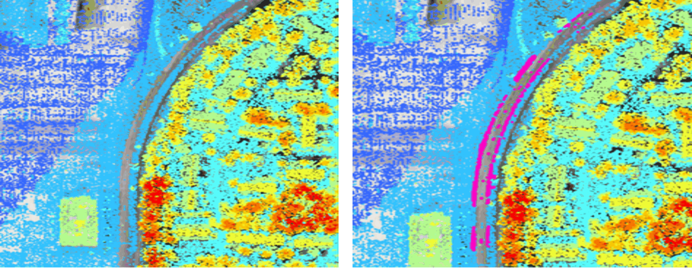
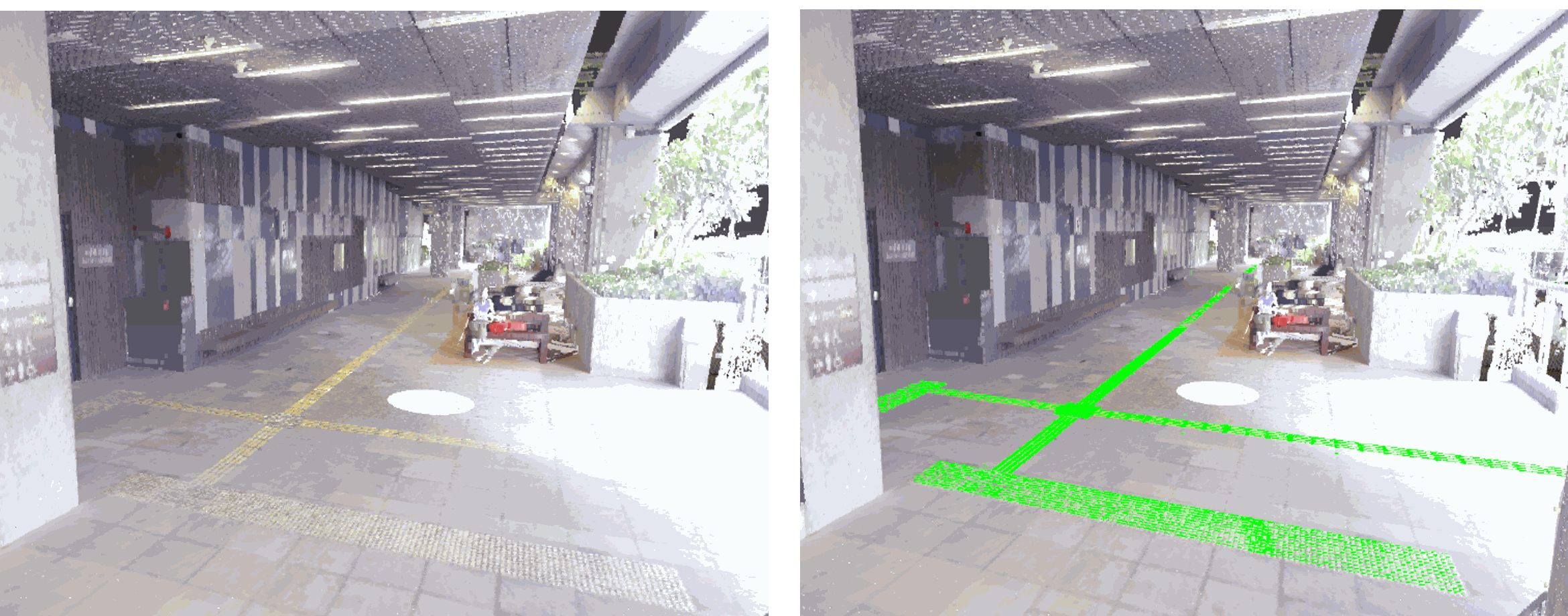
2. "Smart Cities for People with Disabilities: Automatic Construction of Tactile Paving Inventory in LiDAR Point Clouds Based on Computer Vision Approach"
"Towards a digital-twin system for smart mobility for People with Disabilities (PwDs) using multi-data sensing and big data analytics" Funded by Research Institute for Sustainable Urban Development (RISUD), The Hong Kong Polytechnic University, 2021-2024, Dr. Xintao Liu (PI).
Tactile paving inventory is critical in supporting the smart mobility of visually impaired persons. Existing approaches for tactile paving detection vary in effectiveness and accuracy across different scenes. We proposed a computer vision-based approach to extract both indoor and outdoor tactile paving from LiDAR point cloud automatically. This novel approach can effectively construct tactile paving networks, contributing to the development of walkable and inclusive smart cities on a global scale.
Awards and Honors
- Geographic Information System(GIS) top-up prize, Esri China (Hong Kong), 2022.
- Dr Winnie S M Tang-PolyU Student Innovation and Entrepreneurship Scholarship, 2022.
- Innovation Award, PolyU Innovation Challenge, 2022.
- Top Award, Outstanding Dissertation Awards, Hong Kong Institute of Surveyors, 2021.
- First Runner Up & "PolyU Outstanding Work", Student BIM Challenge (Bentley Institute), Sep. 2021. [Link]
- First Prize, Hong Kong Institute of Surveyors Scholarship, Aug. 2021. [Link]
- Dean’s Honours List, 2020 & 2021.
- Wong Kam Fung Scholarship, 2020.
Other Interesting Experiences!
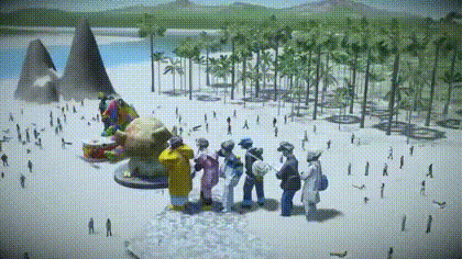
*First Runner Up & "PolyU Outstanding Work", Student BIM Challenge (Bentley Institute)Sculptures 3D Reconstruction: This project is initialized to preserve the value of master art from decay and deterioration over time by capturing the sculptures to digital form. We aspire to make these artistic treasures accessible and appreciated by people across the globe with the immersive capabilities of XR technologies. |
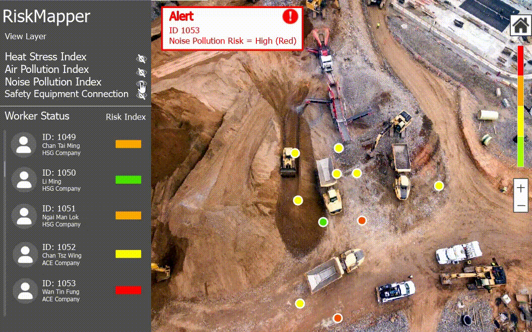
*Geographic Information System(GIS) top-up prize 2022, Esri China (Hong Kong) Developed a risk analysis and monitoring platform with the mission of minimizing
hazards in construction sites while maximizing productivity with Geographic Information Systems (GIS) and Artificial Intelligence (AI).
|